Olympic National Park, East Fork Quinault River Trail - May 19-21, 2018
Olympic Peninsula, Washington, USA

May 21, 2018
Finished an excellent early season backpacking trip exploring the East Quinault River drainage between Graves Creek and the Upper Enchanted Valley in Olympic National Park. Our main objectives were training, surveying, and wildlife viewing.
Weather: Partly cloudy with valley fog layer above 3000-4000 ft. No precipitation. High temperature 18ºC. Low temperature 8ºC. Winds generally calm with diurnal slope winds. Pressure 1015 hPa rising to 1020 hPa.
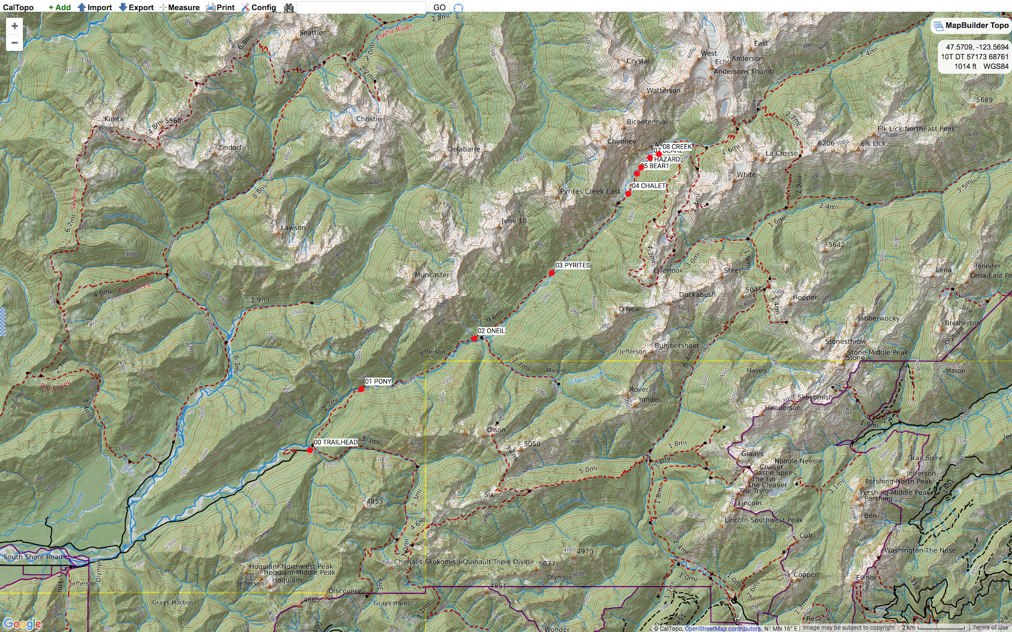
Route: Day 1 - Started at Graves Creek Trailhead, 600 ft GR 570689, and hiked 9.7 mi to Pyrites Creek, 1450 ft GR 676764. Day 2 - Hiked 3.2 mi to Enchanted Valley Ranger Cabin, 2020 ft GR 707797. We explored an additional 1.1 mi into the Upper Enchanted Valley to an unnamed creek, 2320 ft GR 721815. Turning around and retracing our route 4.3 mi back to Pyrites Creek Camp, 1450 ft GR 676764. Day 3 - Egress 9.7 mi to finish at Graves Creek Trailhead, 600 ft GR 570689. (WGS84)
Wildlife: Two herds of Roosevelt elk on the approach drive between Lake Quinault and Graves Creek. Lots of birds, including numerous Pacific wrens, robins, pileated woodpeckers, hairy woodpeckers, a Brewer’s black bird, and many hummingbirds. Our highlight sightings on trail were the two big black bears in the Enchanted Valley. One 0.6 mi past the Ranger Cabin in an open meadow, 2120 ft GR 712807. The second 1.2 mi past the Ranger Cabin in a creek bed, 2160 ft GR 715812. Both encounters were at a safe distance and both bears did not seem stressed by hikers. They continued foraging amongst the grasses minding their own business as we passed.
Hazards: River rerouting has caused significant bank erosion with many fallen timbers 0.8 mi past the Ranger Cabin, 2120 ft GR 713809. The route is tricky to find and there is a fall hazard to consider while scrambling along the new route 30 ft above the river bed. We took great care to make sure each foot placement was on solid ground.
Notes: Perfect weather for backpacking in the rainforest valleys of Olympic National Park! May 2018 has been one of the driest on record in Western Washington. The route was mainly dry with some seepage and tread deep mud in low lying zones with poor drainage. We encountered no snow up to our peak elevation of 2320 ft. The snow line seems to be over 4000 ft with our limited observations due to valley fog. The trail is in excellent shape between Graves Creek Trailhead and Enchanted Valley. All blowdowns cleared, erosion damage repaired, and structures intact. The trail crew was busy brushing, clipping, and raking the route between O’Neil Camp and Noname Creek. Only in Olympic National Park have we witnessed trail crews hand pruning and landscaping a route with such attention to detail and pride of workmanship.
Wilderness Camping Permits are required for all overnight stays in the Olympic National Park wilderness (backcountry) year-round. Obtain permits at the Wilderness Information Center in Port Angeles or at the South Shore Lake Quinault Ranger Station located next to Lake Quinault Lodge. No reservations necessary.
Staging the trip from Victoria involves a 1.5 hour ferry ride and 140 mi drive to the trailhead. To ease the transition from a busy week into a relaxing weekend, we car camped 0.25 mi from the trailhead at Graves Creek Campground, 580 ft GR 564690. Graves Creek is a First Come First Serve campground, with pit toilets, no potable water, and fees are $20/night or $10/night with an Access Pass. This particular weekend the campground was almost empty and a sign on the iron ranger said fees were not being collected. Free car camping and our pick from 25 of 30 sites the night before our backpacking trip was good value.
Our backpacking trips into the rainforest valleys of Olympic Peninsula always offer something special. Great trail networks, abundant wildlife, and beautiful scenery. We are consistently inspired to continue scheming up more adventures in Olympic National Park!
Mike Blake
ACMG HG
mbguiding.ca